Join the waitlist
Join the waitlist

Leave your email and we’ll let you know when you can start walking.

How long would it take to walk every street in Central Coast?

At least
762days
walking 5 km a day·about 2 years
Start colouring in Central Coast
Join the waitlist
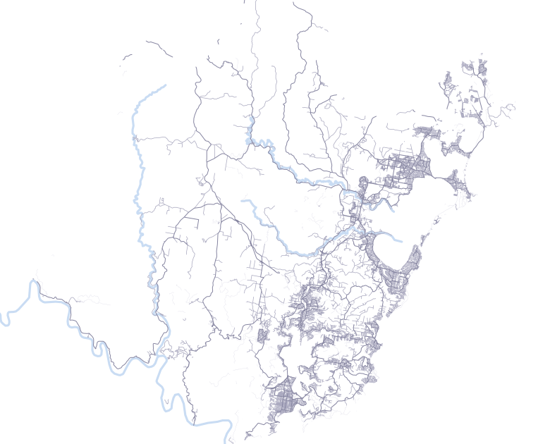
Street map of Central Coast

How many streets does Central Coast have?

Central Coast has 3,809 km of walkable streets and paths, across 4,854 named streets and 149 districts. Walking 5 km a day, it would take at least 762 days (about 2 years) to walk every one of them.

Covers the area inside the official Central Coast Council boundary on OpenStreetMap. Last updated 6 October 2026.

3,809km of streets
4,854named streets
37landmark stamps to collect
149districts

Every street walked once, 5 km a day. Real walks double back, so the true number is a little higher.

Central Coast is the 182nd biggest of the 576 cities on Untrod by length of streets. About 22% of it is paths, footways and steps, close to the 19% of a typical city. Of its districts, Somersby takes longest (28 days) and Mount Elliot is quickest (1 day). The most common street name is Second Avenue: Central Coast has 9 separate streets called that.

Start small

The quickest parts of Central Coast to finish. Each one is a week or two of daily walks.

Alison
Alison2 days
About 1 one-hour walk.5.1 km of streets
Durren Durren
Durren Durren2 days
About 1 one-hour walk.5.2 km of streets
Mangrove Creek
Mangrove Creek2 days
About 1 one-hour walk.5.2 km of streets

Your pace

The same streets at a different speed.

762days
at 5 km a day · about 2 years
1 km a day15 km a day
30 min a dayabout 2.5 km1,524 days
1 hour a dayabout 5 km762 days
2 hours a dayabout 10 km381 days
Weekends only2 hours each day191 weeks

What’s the longest street in Central Coast?

Longest streetWisemans Ferry Road

72.2 km inside Central Coast

Next longestPacific Highway

47.6 km, then Peats Ridge Road at 31.5 km

Most common nameSecond Avenue

There are 9 separate streets called Second Avenue

Street mix
Residential streets 57%2,177 km
Paths and footways 22%826 km
Main roads 21%806 km

Landmarks to collect

37 stamps in Central Coast. Each one is added to your map when you walk past.

33parks
1monument
1ruins
1bridge
Mount Penang ParklandsPark
HMAS ParramattaMonument
Kariong HieroglyphsRuins

Put it in perspective

About 90 marathons
Roughly 5.0 million steps
About 10% of the way around the Earth
More streets than Blacktown, fewer than Logan City

All districts

Central Coast’s 149 districts. Select a column to sort.

Cheero Point1.41
Freemans4.41
Greengrove4.31
Hardys Bay2.61
Horsfield Bay3.11
Kiar1.71
Kingfisher Shores1.41
Lemon Tree4.01
Little Jilliby4.71
Marlow1.11
Mount Elliot4.91
Phegans Bay4.41
Picketts Valley4.11
Point Wolstoncroft1.31
Pretty Beach3.91
Rocky Point1.41
Tacoma South1.31
Upper Mangrove4.41
Wagstaffe3.41
Yattalunga4.01
Alison5.12
Bar Point7.92
Blue Bay5.62
Booker Bay6.12
Box Head6.52
Budgewoi Peninsula6.32
Bushells Ridge5.42
Chittaway Point5.62
Colongra7.02
Doyalson7.52
Doyalson North6.12
Durren Durren5.22
Erina Heights7.72
Frazer Park9.92
Halloran5.42
Kincumber South8.42
Little Wobby6.22
Mangrove Creek5.22
Mooney Mooney7.52
Mooney Mooney Creek8.02
Point Frederick6.22
St Huberts Island6.02
Tacoma7.62
Toowoon Bay8.62
Wallarah6.62
Wondabyne6.22
Woy Woy Bay9.92
Wybung7.42
Wyongah9.82
Canton Beach14.73
Daleys Point10.93
Glenworth Valley13.03
Halekulani13.53
Kangy Angy14.73
Killcare11.13
Killcare Heights12.73
Koolewong12.43
Lower Mangrove11.73
Matcham14.03
Palm Grove11.63
Palmdale11.23
Pearl Beach11.03
Shelly Beach14.63
Tuggerawong10.33
Wendoree Park10.43
Yarramalong13.63
Bensville17.64
Blackwall17.94
Bouddi16.34
Central Mangrove18.84
Chittaway Bay15.44
Davistown16.14
Empire Bay18.64
Fountaindale18.24
MacMasters Beach19.54
Magenta17.44
Niagara Park19.34
Noraville16.14
North Avoca19.54
Saratoga18.44
Spencer16.84
Tascott15.94
The Entrance North16.34
Wyong Creek19.14
Buff Point21.95
Calga20.75
Chain Valley Bay24.85
Charmhaven24.55
Dooralong21.85
East Gosford23.95
Forresters Beach21.25
North Gosford20.75
Patonga22.85
Peats Ridge24.85
Summerland Point22.15
Warnervale24.75
Watanobbi24.85
Budgewoi29.76
Cedar Brush Creek27.26
Copacabana25.66
Glenning Valley29.16
Holgate27.16
Kanwal26.76
Lake Haven26.56
Mount White26.56
Point Clare25.86
San Remo25.96
Springfield29.76
Toukley28.46
Gwandalan31.77
Long Jetty34.87
Mannering Park34.97
Norah Head33.27
The Entrance33.07
Avoca Beach38.68
Gorokan39.18
Gunderman37.28
Mardi37.28
Wadalba37.98
Blue Haven40.19
Ettalong Beach40.09
Gosford43.99
Killarney Vale41.39
West Gosford44.49
Erina48.910
Lake Munmorah48.410
Ravensdale47.810
Tumbi Umbi48.910
Wamberal47.910
Green Point51.611
Mangrove Mountain53.411
Woongarrah58.612
Lisarow62.913
Narara60.313
Berkeley Vale66.514
Kincumber65.814
Kulnura71.615
Jilliby77.316
Kariong79.116
Tuggerah75.016
Wyoming77.116
Wyong77.516
Bateau Bay81.017
Woy Woy83.217
Hamlyn Terrace85.418
Terrigal96.720
Umina Beach95.920
Ourimbah102.321
Somersby135.228

Cities like Central Coast

Nearby, and about the same size.

Questions

What counts as a street?

Every street, lane and path in OpenStreetMap that you’re allowed to walk on, named or not: residential streets, main roads, footways, park paths and steps. Motorways, private roads, driveways and car parks are left out, and so are pavements drawn as separate lines, because walking one already counts for the street beside it.

Why “at least”?

The number assumes you walk each street once, with no doubling back and no walk to get there. Real walks overlap, so it will take a little longer.

Where does the data come from?

From OpenStreetMap, a map of the world made by volunteers. Central Coast’s streets were last updated in October 2026.

What if a street is missing?

Anyone can add it to OpenStreetMap. It will appear here, and on your map in Untrod, after the next update.

How does Untrod track it?

Untrod for iPhone records your location during a walk, and only then, and colours in each street you walk along. Your map is only visible to you until you choose to share it.

Add this number to your site

A small card that links back to this page. Pick the version that suits your site.

<iframe src="https://untrod.app/embed/central-coast?theme=light" width="400" height="220" style="border:0" title="762 days to walk every street in Central Coast"></iframe> <p style="margin:4px 0 0;font:13px/1.4 sans-serif"><a href="https://untrod.app/streets/central-coast">762 days to walk every street in Central Coast</a> · Untrod</p>